Reply With Quote
Looks like you have everyone guessing where your map is at.

 Likes: 0
 Thanks: 0
 HaHa: 0
 Trophy King II

Here's a map that I have been working on. Really explains a lot of things to me about the places I have been catching fish.
Mike

Proud American Patriot
Native Texan
30 Year Navy Veteran
Crappie.com 3K Star General
Looks like you have everyone guessing where your map is at.
Crappie.com 1K Star General
I know those 2 islands. No offense but its pretty useless to anyone who dont know what lake it is...
NWR BASH WINNER
FEBRUARY 2011
SPECKLE DIVISION
Trophy King II
Well, you're wrong and right. Wrong in that you know those 2 islands as there are no islands on the chart. No offense taken, but right in that it isn't any use to anybody but me (for now). It is a work in progress. When finished it might be shared sparingly. Just sayin'.Originally Posted by undertheradar

Mike
Proud American Patriot
Native Texan
30 Year Navy Veteran
Crappie.com Legend
Looked at it and thought it was art work, then I got confused and still am.
"Proud Member of Team Geezer"
Crappie.com Legend
* Crappie.com Supporter
Looks like a sea horse to me.
Sent from my MB860 using Tapatalk 2
Super Mod and 2014 Crappie.com Man of the Year
* Crappie.com Supporter
Panman was working on something like that for Beaverdam.
Fair Winds and Following Seas
Bill H. PTC USN Ret
Chesapeake, Va
Trophy King II
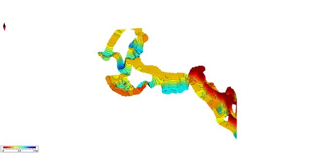
I've done a little more editing and added more data to the map file. I've added depth lines and cleaned some other things up.
Here's a couple more views to help you understand what you are seeing:
Mike
First is a "2d" (flat) view much like you will see when you load it onto a card and put it in your device (ie., Lowrance or Humminbird):
Second is a view that shows the data horizontally so you can see the different depths (i.e., holes, channels and flats):
Last is the same data "tilted" at about a 45 degree angle. Lets you see the different variations from a different perspective:
Proud American Patriot
Native Texan
30 Year Navy Veteran
Crappie.com 1K Star General - Sponsor
The Dr. Depth website (yes, it's a Sweedish company) illustrates and explains this mapping product fairly well.
Posting Permissions