 Likes:
  Thanks:
  HaHa:
HaHa: 

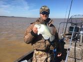
There's no surefire way to prevent disasters, but it is a great help to save a lot of acres from getting wet

 Crappie.com Legend

There's no surefire way to prevent disasters, but it is a great help to save a lot of acres from getting wet
Crappie.com Legend
But its sad they still use the early 1970's flood as there guide. Because if we get that kind of rain again. No dam is going to help with the floods we will have again.
Do wish they would hold a little more water in the winter time. But then again they could care less about fishing. Same as TVA here at Pickwick Dam.
Crappie.com 1K Star General
I guess what I was trying to figure out is IF they suspect the MS river has a high potential to flood say a month from now, would they allow the lakes to go below rule curve just as a precautionary measure to have the ability to hold more water back if necessary? Always amazed me how they can predict river stage levels downstream. Guess that's where all that fancy math I couldn't comprehend comes in.
LivetoFish
Crappie.com Legend
They wont drop it below curve because of what the MS river may or may not do. Really they werent built to take the pressure off the MS but to take the pressure off the river bottoms below the levies. 2 inches of rain in a 24 hour period is an automatic shut down at Grenada because of what will happen down stream several miles. They are actually holding Grenada rite now a couple feet above curve, why? Who knows?
1990 Stratos 285 Pro 200 HP Merc
SpyderLok Rod Holders
Proud Member of Team Watch The Finger!!!
(662) 458-8925
Crappie.com 1K Star General
Slabmaster
The level of the Mississippi river has everything to do with the level in the four reservoirs. The only place water can get into the Mississippi river is at Vicksburg through the Yazoo pass. If the Mississippi is high enough the reservoirs will hold water to prevent flooding all the way down the Yazoo tributary and the Mississippi below Vicksburg. The same thing happens across the river with the only place water can get in the Mississippi is the Arkansas River.


 Reply With Quote