The United States government currently claims 4 meter RMS (7.8 meter 95% Confidence Interval) horizontal accuracy for civilian (SPS) GPS. Vertical accuracy is worse. Mind you, that's the minimum. Some devices/locations reliably (95% of the time or better) can get 3 meter accuracy.
So, the "best" possible outcome is within ~10ft of your waypoint (with civilian GPS units)
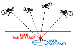
That's what makes single point waypoint marks (on small objects) so hard to return to by GPS alone. But, if you do pass over it with 2d or DI and throw out a marker buoy to both sides ... you won't have to keep trying to find it with your depth finder while fishing it.
You also have to remember that your depth finders are not 100% dead accurate, either. 2d & DI will both only show you how far an object is from the transducer, and you have to consider the cone angle (2d) and the angle of the DI fan shaped ping (which depends on which kHz setting you're on), plus the fact that neither one tells you which side of the transducer the object is on ... it just tells you that the object is within the area of the ping shape of whichever mode is being used.

 Likes:
  Thanks:
  HaHa:
HaHa: 


Originally Posted by CrappiePappy


 Reply With Quote


